
George Bush Intercontinental Airport is massive. With five terminals, over a hundred gates, and two transit systems, it is incredibly easy to get completely lost, especially if you are rushing between Terminal A and Terminal E for a tight connection.
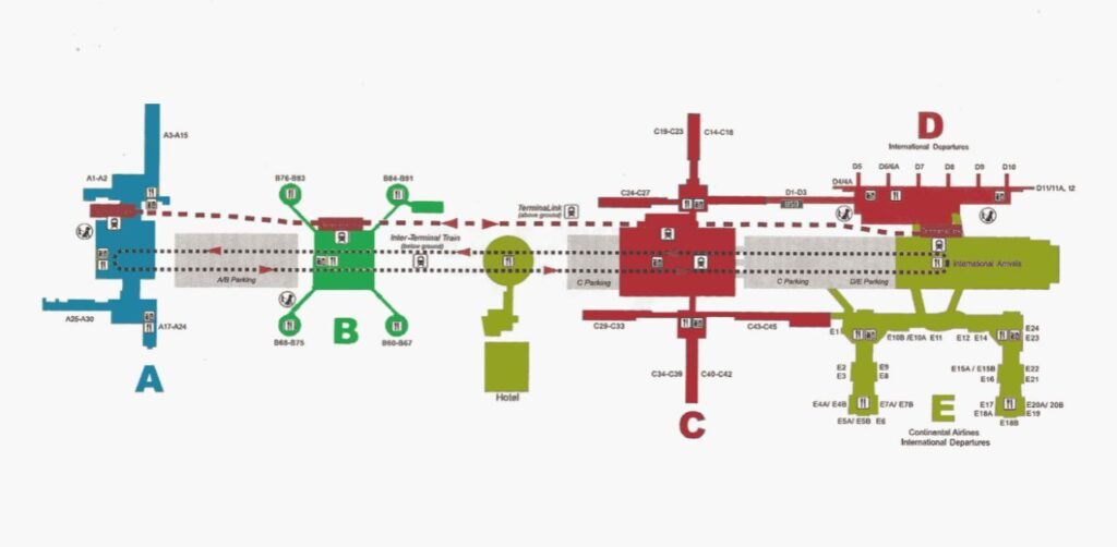
Luckily, the airport has a great digital tool to save your sanity. Using the IAH Airport map makes navigating the halls way less stressful. This guide gives you an insight into how to use the map to find your terminal layout, master the trains, park easily, locate accessibility spots, and track down the best food.
The IAH Airport Terminal Map — What It Actually Does
Getting lost at Houston’s massive airport is incredibly easy when you’re rushing for a flight. Luckily, the live map of IAH Airport provides step-by-step directions right on your phone so you can skip the stress.
- Where to find it: Head directly to iahmaps.fly2houston.com, check the “Airport Info” menu on fly2houston.com, or open the official IAH mobile app (available on Apple and Google Play).
- How it actually helps: Forget useless, flat PDFs. This live map gives you real step-by-step directions from your exact spot to your next gate, shop, or lounge.
- Real-time updates: It maps out the entire terminal layout, showing you live walking times, parking spots, and handy amenities along your route.
- Instant access inside: Look around the terminal for physical QR codes. Scanning one pulls up the map instantly on your phone so you can get moving right away.
What the IAH Interactive Map Covers
IAH has five terminals: A, B, C, D, and E. Understanding which terminal you’re in and which terminal you need to reach is the foundation of navigating the airport. Here is how the gate numbering breaks down based on the George Bush Airport terminal map:
| Terminal | Gates |
| Terminal A | Gates A1 – A30 |
| Terminal B | Gates B1 – B88 |
| Terminal C | Gates C1 – C45 |
| Terminal D | Gates D1 – D12 |
| Terminal E | Gates E1 – E24 |
- Terminals D and E are typically referenced together (D/E) for transit connections. The official terminal directory also notes that International Departures and International Arrivals are routed through specific sections of the terminal layout, which is relevant if you’re connecting from or to an international flight.
- For the most accurate layout, including temporary changes during any ongoing redevelopment, the live interactive map at iahmaps.fly2houston.com is always more up-to-date than any static document.
IAH Terminal Transfers — Skyway and Subway Options
This is the part of IAH that confuses most first-time visitors. The airport has two completely separate transit systems running simultaneously, and which one you need depends entirely on whether you’ve already gone through security.
The Skyway — Above Ground, Inside Security
The Skyway is the above-ground train that connects terminals once you’re airside. According to the official IAH Skyway and Subway page:
- It departs at two-minute intervals from terminals A, D/E, and C.
- It is completely free to use
- The Skyway operates every day with no closed hours listed
- The total travel time between terminals A and D/E stations is 4 minutes and 15 seconds
- Signage for the Skyway stations is clearly marked as “Skyway” throughout the terminal.
If you’re making a connection and you’ve already cleared security, the Skyway is your tool. Four minutes and fifteen seconds from one end of the terminal system to the other is genuinely fast for an airport this size.
The Subway — Below Ground, Outside Security (Pre-Security)
The Subway runs underground and is the right option when you haven’t gone through security yet, when you’re arriving and heading to pick someone up, or when you’re trying to reach the Airport Marriott hotel from the terminal side.
- It departs at a three-minute interval from the following locations: Subway stations at terminals A, D/E, and C.
- Completely free to use
- Operating hours: 3:15 a.m. to 12:15 a.m. daily — it does close between 12:25 a.m. and 3:15 a.m.
- Trip time between one station and the next: approximately 3 minutes
If you’re arriving late at night after 12:25 a.m. and the Subway is closed, plan to walk or use ground transportation. This is worth checking before a very late arrival, especially if you need to reach a different terminal before collecting your bags.
The interactive map shows you exactly where both Skyway and Subway stations are located relative to your current position in the terminal, making it much easier to find the nearest access point than trying to follow corridor signs while carrying luggage.
Driving to IAH — Address and Route Information
The George Bush Airport map also helps travelers understand how the airport connects with the surrounding highways. The airport is approximately 22 miles north of downtown Houston, making it the farthest of the Houston metro airports from the city center, yet well connected by major highways.
The airport is accessible from:
- Interstate 45
- U.S. Highway 59 (Interstate 69)
- Hardy Toll Road
- Sam Houston Tollway (Beltway 8)
The two primary approach routes to the terminals are John F. Kennedy Boulevard (accessible from both the Sam Houston Tollway and the Hardy Toll Road) and Will Clayton Parkway (accessible from U.S. Highway 59/Interstate 69). The airport specifically recommends using the official address in your GPS navigation to ensure accurate routing.
Parking Made Easy with the George Bush Airport Map
IAH offers several parking options, all of which appear on the IAH Airport map.
Below you can find the available categories:
| Parking Option | Best For / Key Feature | Details & Important Rules |
| Valet Parking | Fastest path to terminals | Curbside drop-off service where airport staff handles parking for maximum convenience. |
| Parking Plus | Convenience & cover | Covered, upgraded parking options located closer to terminal entrances than standard economy lots. |
| ecopark2 | Budget & long-term stay | Reservation-only as of June 1, 2026. Pre-booking is required as walk-ups are not accepted once garage capacity hits 85%. |
| EV Charging | Electric vehicle owners | Dedicated charging stations available while you travel; exact locations are viewable on the interactive map. |
The airport’s advice is clear: the best way to guarantee parking is to make a reservation before you travel. Walk-up availability is not guaranteed, and the ecopark2 reservation requirement makes this more important than it used to be.
Use the IAH Airport Terminal Map to Find Shops, Dining, and Lounges
Hunting for a bite to eat or a last-minute shop is a nightmare when you’re stuck in a massive airport. Thankfully, the live map lets you filter through every single terminal to spot exactly what you need without walking miles.
- Find exactly what you want: Filter the map as per category so that you get the exact location that you want.
- Tons of options: The official list includes spots like Urban Crave, Chili’s, and Auntie Anne’s, along with 24-hour options for late flights.
- Check the details: Every venue meets accessibility guidelines, though you’ll want to use the map to check individual store hours since they vary.
- Save your feet: Instead of wandering blindly between concourses, use the map to see which terminal has your specific craving before you start walking.
Accessibility Features on the George Bush Airport Terminal Map
You will find several accessibility facilities at the airport to accommodate passengers with visible as well as non-visible disabilities.
| Service / Feature | Description | Key Locations & Access Details |
|---|---|---|
| American Sign Language Interpretation | ASL interpretation services for deaf and hard-of-hearing passengers. | Available upon request across airport terminals. |
| Aira Services | On-demand, visual navigation assistance for blind and low-vision (BLV) travelers via smartphone app. | Available airport-wide. |
| Skyway Access | Fully accessible above-ground automated train linking terminals post-security. | Above-ground transit stations connecting all terminals. |
| Accessible Parking | Designated ADA parking spaces for vehicles with valid disability permits. | Located in all airport parking garages; visible on the interactive map. |
| Accessible Restrooms | ADA-compliant restrooms designed with wide entries and appropriate fixtures. | Positioned throughout all terminal concourses. |
| Security Screening Accessibility | Dedicated TSA support and assistance during security checkpoint screening. | Available at designated security checkpoints. |
| Mother’s Rooms | Private, quiet nursing facilities equipped for mothers and infant care. | Located within main terminal areas. |
| Sunflower Lanyard | Program allowing travelers with non-visible disabilities to discreetly signal staff for extra time or support. | Pick up at Information Booths or request via email before travel. |
| Wheelchair Services | On-site mobility assistance and wheelchair escort services through the airport. | Available via airline request or at airport drop-off points. |
| Sensory Rooms | Calming, low-stimulation spaces designed for travelers needing a break from terminal noise. | Located in Terminal A (inside Mother’s Room near Gate A2) and Terminal D (West Pier). |
| Pets & Service Animal Relief | Dedicated relief areas for service animals and traveling pets. | Active: Curbside Zone 4, Level 1 Arrivals. (Note: Gate 21 area temporarily closed). |
For passengers who need formal accommodations from the airport, it provides a downloadable Reasonable Accommodations form and links to the Houston Airport’s ADA Policy and Grievance procedure, as well as the City of Houston’s ADA Policy.
The IAH Mobile App — Map in Your Pocket
The map of IAH Airport is fully integrated into the official Houston Airports app.It’s listed on both the Apple App Store (App ID: 1613307854) and the Google Play Store. The app gives you the same wayfinding capabilities as the browser-based interactive map, with the added convenience of having it on your phone as you move through the terminal. The airport’s official website specifically highlights the app as the way to get all options at your fingertips.
Useful Contacts for When the Map Isn’t Enough
Sometimes you need a person rather than a screen. IAH officially lists the following:
| Service / Channel | Purpose | Direct Web Link / Handle |
| Lost & Found | Report or search for missing personal items at the airport | fly2houston.com/iah/lost-and-found/ |
| General Contact | General inquiries, passenger support, and directory | fly2houston.com/iah/contact/ |
| Airport Alerts | Live operational updates, construction notices, and travel disruptions | fly2houston.com/iah/alerts/ |
| Real-time social updates, announcements, and news | @BushAirport | |
| Visual updates, passenger tips, and airport features | @bushairport | |
| X (Twitter) | Fast customer service responses and instant flight/terminal alerts | @iah |
Conclusion
IAH is massive, and there is no pretending otherwise. But using the map of IAH Airport genuinely takes all the stressful guesswork out of your travel day.
Whether you need to figure out the right Skyway stop, check where your parking garage is located next to Terminal C, or hunt down a quiet sensory room before a long flight, the live map at iahmaps.fly2houston.com has you covered in real time. Pull it up before you leave the house and check it again when you land; it is the easiest way to make this huge airport feel completely manageable.
Commonly Resolved Queries!
Q. How do I access the Interactive Map of IAH?
A. You can open it right on your phone browser by visiting the website or downloading the official Houston Airports mobile app from the store.
Q. Does the map give me directions between different terminals?
A. Yes, the map gives you clear directions and transit routes to help you navigate easily between all five of the different terminal buildings.
Q. Can I use the map to find restaurants and shops?
A. Absolutely, you can easily filter the live terminal map by category to quickly locate dining spots, coffee shops, retail stores, and operating hours.
Q. Will the interactive map help me find airport parking options?
A. Yes, it marks out all the different parking garages and lots, making it simple to find where to park near your specific terminal.
Q. Does the map show the locations of restrooms and lounges?
A. Yes, you can use it to quickly pinpoint everyday necessities like restrooms, charging stations, nursing rooms, baggage claims, and airline lounges across concourses.