
DFW Airport is the main international hub for the Dallas-Fort Worth area in Texas. Geographically, it sits 16 miles outside of Dallas and 20 miles away from Fort Worth. Moving through this airport can be intimidating because of its massive size and constant crowds. To fix this, you can rely on this reliable guide of the Dallas/Fort Worth International Airport map to find your way. A map helps you find gates, luggage areas, and parking without stress.
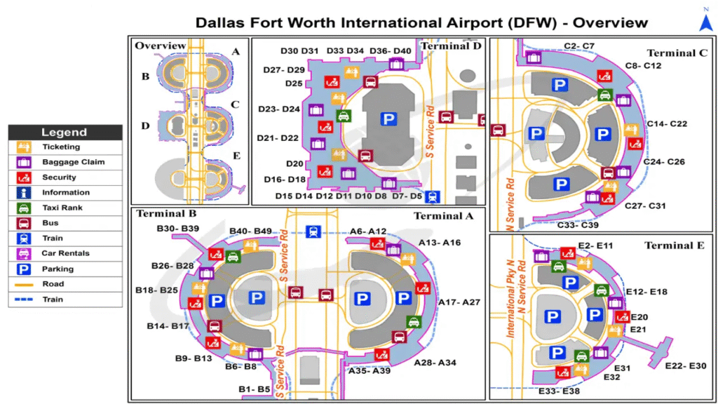
In this guide, we provide a simple overview of the DFW Airport Map to help you navigate the space with ease.
Benefits of Using the DFW Airport Map
The DFW Airport map helps passengers quickly understand the airport layout before arriving. Since the airport has multiple terminals and several levels inside each terminal, the map can guide travelers to several facilities like check-in counters, ATMs, restrooms, ground transportation services, baggage claim areas, and more.
So, instead of walking around searching for your gate or terminal, you can simply follow the map and reach your destination faster.
Learn About Dallas/Fort Worth International Airport Through the Interactive Map
DFW Airport has five main terminals: A, B, C, D, and E. Each terminal has different levels designed for departures, arrivals, Skylink access, and other airport services.
- Terminal A
Terminal A includes Skylink at Level 3; departures and check-in at Level 2; and the lower level at Level 1. Other facilities include restrooms at Level 2, charging stations near gate A 22, a water refill station near gate A 23, and more. Check the map for a more detailed insight.
- Terminal B
Terminal B features Skylink at level 3; departures and check-in at level 2, and the lower level at level 1.
You can use the map to locate ticketing areas, baggage services, and terminal exits without confusion. You will also find SmarteCartes near the baggage claim, restrooms near B 28, charging stations near B 29, and more. ,
- Terminal C
Terminal C has a slightly larger layout, with the Skylink at Level 4, a mezzanine at Level 3, departures and check-in at Level 2, and a lower level at Level 1.
The airport map is especially useful here because the extra mezzanine level can sometimes confuse first-time visitors. Besides this, there are several shops and restaurants at Terminal C, and you will also find services such as a women’s restroom adjacent to C 24 outside security, a men’s restroom near C 24, pet relief areas, and more.
- Terminal D
You will find Skylink on level 5, the mezzanine on level 4, departures and check-in on level 3, and baggage claim on level 1. The terminal is also equipped with several services like valet parking, ATMs, restrooms, and more.
- Terminal E
At this Terminal, you can locate the Skylink at Level 3; departures and check-in at Level 2; lower at Level 1; and the tunnel at Level 1.
The map makes it easier to navigate between levels and locate the underground tunnel area.
How Does DFW Interactive Map Help You To Navigate the Terminal Fast?
The DFW Airport map makes it easy to find rides outside. To do this, it highlights all the shuttle stops and parking areas. Furthermore, it easily points the way to transit stations and rental car buildings.
- Airport Shuttle Tracker
You can easily avoid long waits when moving between terminals outside the secure area. To do this, check the live arrival times for the Terminal Link shuttles. After that, you can time your walk perfectly and jump right on. It’s simple, you can enter your pick-up and drop-off location and then view the live shuttle map.
- Directions and Pick-Up & Drop-Off
DFW Airport is connected to major roads and highways, so it is very easy for drivers to get there. Also, the map helps visitors find the exact pick-up and drop-off areas at each terminal.
- Construction Updates
Sometimes, airport construction alters the regular driving routes. Therefore, you should look at the airport map before your trip. As a result, you can stay on top of changes and save time when entering or exiting. You check various apps to navigate construction sites. These include the DFW Mobile App (IOS and Android), and more. You also have the option to sign up for the MyDFW community to receive updates on construction and the latest airport news.
- Parking at DFW Airport
The airport has a few parking lots right next to the terminals. In addition, you can use the map to easily find the garages, entrances, and walking paths to your gate. Best of all, if you book your spot in advance, you will save both time and money.
- Rental Cars
If you need a car, DFW Airport has a rental facility right on the property, easy to spot on the map. To get live updates, check the shuttle tracker tool on DFW’s official website. Enter your locations for pick up and drop, and you will be good to go.
- Ground Transportation Services
You can use the map to locate:
- Taxis
- Ride-share pick-up areas
- Hotel shuttles
- Charter buses
- Limousine services
This makes leaving the airport much more organized and stress-free.
Get to Your Airline Faster at DFW Airport with the Map:
You can quickly find your terminal and gate with the DFW Airport map. The map also shows the fastest SkyLink train routes. Finally, it locates nearby parking and security checkpoints to save you precious time.
| Terminal | Airline | Gates |
| Terminal A | American Airlines | A8- A39 |
| Terminal B | American Airlines | B1- B49 |
| Terminal C | American Airlines | C2- C39 |
| Terminal D | AeroMexico | D6- D16 |
| Air France | D6- D16 | |
| American Airlines | D17- D40 | |
| Avianca | D6- D16 | |
| British Airways | D6- D16 | |
| Emirates | D6- D16 | |
| Japan Airlines | D6- D16 | |
| Korean Air | D6- D16 | |
| Lufthansa | D6- D16 | |
| QANTAS | D6- D16 | |
| Qatar Airways | D6- D16 | |
| Sun Country Airlines | D6- D16 | |
| Viva Aerobus | D6- D16 | |
| Volaris | D6- D16 | |
| Terminal E | Air Canada | E2 |
| Alaska Airlines | E11 | |
| American Airlines | E35- E38 | |
| Delta | E12- E17 | |
| Frontier Airlines | E20 | |
| jetBlue | E10 | |
| United Airlines | E4- E9 |
How to Use the DFW Airport Map Without Confusion?
Here are a few simple tips to make your trip smoother:
- Checking the airport layout in advance helps you visualize your route, reducing stress and making navigation much easier upon arrival.
- Flight details change frequently, so verify your gate and terminal on the airline app to avoid wandering the wrong way.
- Hop on the free Skylink train to quickly travel between terminals instead of walking, saving you time and physical effort.
- Find a place to park or catch rideshares before leaving home so you can head straight there without getting lost.
- Pay close attention to overhead signs for departures, arrivals, and baggage claim to ensure you are on the correct floor.
- Give yourself extra time during holidays or peak hours to comfortably handle long security lines and unexpected delays.
Simple DFW Map Tricks Every Traveler Should Know
Here is what we need to keep in mind:
- The Golden Connection Rule: Make sure you have at least 45 minutes between U.S. flights and 90 minutes for flights abroad. The Skylink train saves time, but walking through a single terminal can still take up to 10 minutes.
- Security Line Flexibility: You can pass through security at any DFW terminal because the Skylink train connects them all on the inside. If Terminal C has a long line, check the app, go through Terminal A or D instead, and ride the train to your gate. To get real-time security wait times, check DFW’s official website.
- Intra-Terminal Walking Paths: If you prefer to walk for exercise between flights, indoor pedestrian walkways connect terminals A-D.
DFW Airport is just a main road with five loops. Remembering this layout will make your next trip completely worry-free.
Conclusion:
After reading this guide, you will have understood that the DFW Airport map is one of the best tools for any traveler. DFW is a very large airport with many terminals and different levels, but the map helps you avoid confusion and save time. It allows you to travel with peace of mind. The map makes it easy to locate everything you need, including check-in counters, baggage claims, Skylink stations, and taxis or buses. This useful tool makes airport travel a walk in the park for everyone.
FAQs:
DFW Airport is located in Texas, 16 miles outside Dallas and about 20 miles from Fort Worth.
The airport features five main terminals, named A, B, C, D, and E, for travelers.
Yes, indoor pedestrian walkways allow you to walk easily between Terminals A and B, and between Terminals C and D.
Yes, you can easily catch trains headed to Dallas or Fort Worth from stations located at Terminal A and Terminal B.
The map helps you find gates, baggage claims, parking zones, and ground transportation without getting confused or lost at DFW Airport.